The Best 16 Islands In Alaska You Have To Visit
Is it possible to go island hopping in Alaska? You certainly can! Even if it’s not tropical, it doesn’t make it any less stunning.
The islands of Alaska are among the world’s most pristine locations, and they provide a challenging but spectacular playground for adventurous tourists. With these islands, visitors will enjoy sand beaches, magnificent views, volcanic formations, and endless opportunities for outdoor fun.
Alaska is definitely a state that defies the trend with more than 2,600 identified islands and 6,640 miles of coastline for island living. We’ve narrowed them to give you the top 17 Alaskan islands, each of which has something unique to offer visitors.
16. Adak Island

Adak Island is a volcanic island in the middle of Alaska’s Aleutian Islands’ long arc. Adak’s rough yet spectacular arctic landscapes, challenging climate, diverse plants and animals, and rich history make it an appealing destination for adventurous trekkers, birders, and hunters. All around, this is one of the best islands in Alaska to visit!
The island’s land area is 274.59 square miles, with a length of 33.9 miles and a width of 22 miles, ranking it as the 25th biggest island in the United States.
Due to the fierce winds, frequent cloud cover, and freezing temperatures, the vegetation at lower altitudes is mostly tundra (grasses, mosses, berries, and low-lying floral plants). On the island’s northwest edge, Mt. Moffett is the island’s highest peak, standing at 3,924 feet. It is snow-covered most of the year.
Alaska Airlines has two weekly flights to Adak, and most visitors—perhaps 400 per year—come for caribou or birds. The Alaska Maritime National Wildlife Refuge maintains a small office in the harbor, and the refuge’s research ship utilizes the port to exchange crews with biologists stationed in Aleutian field sites.
If you come, consider that approaching private Aleut Corporation grounds (those not accessible by road or path) needs a permit.
15. Baranof Island

Baranof Island, also known as Baranov or Sitka Island, is located in the Alaska Panhandle’s northern Alexander Archipelago. It is well-known for its brown bears and Sitka deer, and its primary businesses are fishing, seafood processing, and tourism.
Baranof is the smallest of Alaska’s islands, with an area of 4,162 square kilometers and a population of less than 9,000. The majority of it is contained inside the boundaries of Tongass National Forest. It is around 170 kilometers by 50 kilometers, has a coastline of approximately 1,000 kilometers, and is home to the Alexander Archipelago’s tallest mountain.
Sitka is the island’s biggest city and the largest city in the United States in terms of physical size – thus, there is plenty of space to spread out! If you arrive by boat in Sitka, you’ll need to take a cab or shuttle into town. If you fly into Sitka, the airport is a little over a mile from the downtown area. You’ll pass a bridge that views islands and fishing boats, a characteristic landscape of the Southeast. Sitka is a somewhat walking town; trails and beaches are readily accessible.
At the end of Sawmill Road, a 1.6-mile easy-to-moderate route, the Herring Cove Trail takes you through lovely forests and many waterfalls.
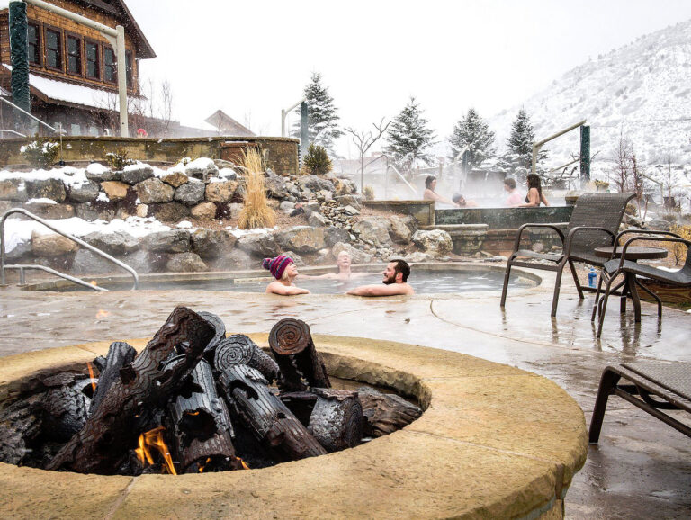
Baranof Warm Springs, a tiny bit of wilderness paradise, is a natural hot spring nestled behind a magnificent waterfall; you’ll feel like the only person. Hike up the path and paddle around a picturesque alpine lake. A short 20-45 minute flight from Sitka, this location is ideal for a relaxing “Spa Day.”
While this is one of the smaller Alaskan islands, it’s easy to get to and is really beautiful!
14. Chichagof Island

Chichagof Island, just off the coast of Juneau, is ripe for exploration. This 2,050 square foot landmass is home to the world’s largest bear population per square mile and the settlements of Hoonah, Pelican, Tenakee Springs, and Elfin Cove. As the fifth-largest U.S. island, Chinchagof is one of Alaska’s best-kept secrets. And if you want to see bears, this is one of the best Alaskan islands to check out.
Explore the Tongass National Forest’s rough landscape for a once-in-a-lifetime adventure! While Hoonah Travel Adventures cannot promise to show you a bear, you will have a significant probability. Consider scheduling the Wilderness Tour and Brown Bear Search if you want to spot a bear.
You might visit Hoonah, Alaska’s biggest Tlingit community, to get a vibe of the island. The Taste of Hoonah and City Tour begins with a stroll around the town. You’ll hear about the history and people before arriving at Icy Strait Lodge, where you can have an Alaskan beer and a sampling trio of locally sourced seafood.
Silverbow Inn Hotel & Suites is the ideal spot to unwind after a day of touring the island. They will provide all the essential equipment if you’re into the outdoorsy excursions, so your adventurous attitude is all you need to bring. The Pack Creek Grizzly Bear Viewing Seaplane Adventure is one of their many offers and packages. The day begins with a 25-minute aircraft journey, followed by five to six hours of grizzly viewing from a private viewing spot. It’s our favorite thing to do on this Alaska island!!
13. Unga Island

Unga Island is the biggest Shumagin Alaska Island, located southwest of Alaska’s Alaska Peninsula. Although the island is deserted, it is a popular day-trip destination because it has a unique petrified forest, one of the Aleutians’ most significant abandoned settlements, and a gold mine remains.
Petrified logs and stumps exposed along the beaches of Unga Island are relics of a sequoia or metasequoia forest that was buried during the Tertiary Period due to volcanic activity.
The petrified forest remnants are significant scientifically because they provide light on species migration between Asia and America and help paint a picture of the Aleutian Arc’s temperature and habitat before the arrival of people in Alaska.
Sand Point is a lovely area that attracts hikers owing to its bear-free status. The island is accessible by boat from neighboring Popof island, home to the area’s main town at Sand Point on the northwest shore. Birdwatching is another popular sport on the island, home to an abundance of bird species, including eagles, puffins, cormorants, and kittiwakes.
12. Fox Island

Fox Island in Resurrection Bay seems wonderfully secluded while being just 12 miles from Seward. This beautiful, isolated Alaskan island is only accessible by boat (on Kenai Fjords Tours). Also, the island is a lovely experience for foodies, kayakers, and wildlife enthusiasts.
Just outside Kenai Fjords National Park, Fox Island’s tranquil seas, beaches, and walking pathways provide stunning views of the flora and animals. Regardless of the trip duration, departure time, or components you choose, you will see a diverse range of animals and glaciers.
Each trip starts with a voyage aboard a custom-built yacht intended explicitly for wildlife and glacier watching with comfortable internal seats, large picture windows, and multi-level, walk-around viewing decks outside.
The National Park Service rangers on Fox Island can teach you about the island’s history, or you can go beach-combing, shop for souvenirs, or simply relax. There’s also an all-you-can-eat Alaska salmon and prime rib entrée, salad, veggies, and dessert if you visit the island around lunch or dinner. And wow – this food is seriously fresh!
If a day trip to Fox Island isn’t enough for you, the Kenai Fjords Wilderness Lodge, a luxurious high-end experience that is also “unplugged” (without T.V.s or phones) is available for overnight or multi-night stays. You’ll enjoy a private beachfront cottage, delicious meals, and guided island walks/hikes when you book an all-inclusive vacation.
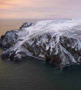
11. Bogoslof Island

Bogoslof Island is the biggest group of tiny, low-lying Alaskan islands that form the top of a vast undersea stratovolcano. This stratovolcano rises around 6000 feet from the Bering Sea seabed but reaches a maximum elevation of just about 300 feet above sea level.
The location of the Bogoslof volcano is peculiar. It is located somewhat north of Aleutian’s main volcanic front and is considered a back-arc structure. This volcano is regularly transformed by eruptions and erosion and has changed dramatically over history.
Fire Island is a small sea stack located around 2000 feet northwest Bogoslof. As it exists now, Fire Island is the remnants of a volcanic dome that extruded in 1883.
Bogoslof is triangular and is around 1.2 miles by 0.5 miles. On Bogoslof’s southwest face are steep-sided twin pinnacles known as Castle Rock; they are the remnants of a dome that erupted in 1796. On the north end of Bogoslof Island, a small dome measuring 500 ft by 900 ft erupted in 1992. Additional domes erupted at Bogoslof but were destroyed by explosions or erosion.
This island is tough to reach and is seldom seen owing to fog and weather, but if granted access, there are incredible possibilities to watch stellar sea lions and northern fur seals. Also, it is home to breeding sites for approximately 50,000 murres, kittiwakes, and other marine birds. It’s one of the best islands in Alaska to catch visuals of wildlife!
10. Kodiak Island

Kodiak Island is a massive island off the coast of Alaska, separated from the mainland by the Shelikof Strait. It is the most oversized island in the Kodiak Archipelago. With a surface area of 3,588 square miles, it is Alaska’s most famous and second-largest island (after the Big Island of Hawaii). It stretches for 100 kilometers and varies from 10 to 60 miles.
The north and east of Kodiak Island are hilly and extensively wooded, whereas the south is sparsely vegetated. The Kodiak National Wildlife Refuge covers the southern two-thirds of the island, as most Kodiak Archipelago. Many ice-free, deep bays dot the island, providing safe anchoring for boats.
Kodiak Island is surrounded by some of the world’s most prolific fishing areas, and fishing is the island’s most significant business. Pacific salmon, Pacific halibut, and crab are among the fisheries. The salmon run on the Karluk River is well-known. There is also logging, livestock, many canneries, and some copper mine. The island’s natural species include the Kodiak Bear and the King Crab.
The natural beauty of Kodiak Island is breathtaking. Its warm coastal climate and high precipitation have produced a wilderness suitable for land, sea, and marine life. Because of the lush greenery that blankets the area, residents and tourists affectionately refer to it as the “Emerald Isle.”
9. Pennock Island

Pennock Island is a small island off the coast of Alaska, near the town of Ketchikan. The island is part of the Alexander Archipelago and is located within the Ketchikan Gateway Borough. The Tongass National Forest manages the majority of the island as public property.
Pennock Island is located between Gravina Island and Revillagigedo Island at the eastern end of the Tongass Narrows, dividing the waterway and dividing the channel into East and West Channels. It’s low-lying and forested, with a steep south coast. It is about 3 miles long east-west and 0.25–0.625 miles wide.
The east end of the island is roughly 0.5 miles from California Rock. You can locate the islet of East Clump off the island’s west coast. Pennock is a small town at Whiskey Cove, just across from Coast Guard Station Ketchikan. There are just a few buildings hidden within the densely wooded forest; human occupancy is sparse.
Pennock Island hosts the annual “Pennock Island Challenge,” which began in 2004. The event is being conducted to benefit the JDRF. The 8.2-mile race circuit winds its way around the mountainous island in a round style.
There are solo and relay races and wet suit and non-wetsuit teams. Boat escorts and kayak escorts are required. Swimmers competing in the event are cold water experts since the water temperature ranges between 55–60 °F throughout the race.
8. Sebree Island
Sea kayaking and camping are popular activities on Sebree Island, located just east of Muir Inlet and west of Tlingit Point. You can also explore the region from a charter/tour boat or a private vessel during a one-day excursion.
Common species seen are Surf Scoters, White-winged Scoters, Black Oystercatchers, Pigeon Guillemots and Marbled and Kittlitz’s Murrelets, and the Tufted Puffin, Horned Puffin, Black-legged Kittiwake, and many more.
You can either take a tour/charter boat or a private vessel from the public dock at the National Park Visitor Center with permission to visit the Sebree Island Area. Those with experience paddling and camping outdoors can also use sea kayaks to explore Glacier Bay, including the Sebree Island region.
Some tour operators can help you get kayaks to some of the most isolated areas of the park. The National Park Service can assist you in finding licensed tour operators.
From downtown Gustavus, continue west on Gustavus Road toward Shooting Star Road (0.7 miles); turn right onto Mountain View Road and proceed 2.8 miles to Park Road. The Glacier Bay Visitor Center is 4.4 miles away if you stick to the signage.
7. Round Island

During the summer, hundreds or possibly thousands of Pacific walruses rest on the rocky shorelines of this rugged, steep, and inaccessible island, making it Alaska’s most incredible spot for seeing and photographing them.
Round Island, which is part of the Walrus Islands State Game Sanctuary in southwest Alaska’s Bristol Bay, is home to tens of thousands of seabirds, including puffins, murres, and kittiwakes, as well as Steller sea lions and other terrestrial and marine animals.
While walruses are generally present from May to August, their numbers decrease as the summer advances, so visit between late May and mid-July when the weather is usually better (though this is relative — coastal weather in southwestern Alaska is often windy and rainy).
Visiting is only for the brave since it includes flying in tiny aircraft and boats and camping in a remote location; yet, it is an unrivaled wildlife and wilderness experience for those willing.
The Alaska Department of Fish and Game oversees the sanctuary’s operations.
To reach the sanctuary, take a commercial aircraft from Anchorage to Dillingham, then a 25-minute local commuter flight to the village of Togiak, followed by a 35-mile boat taxi to the island. There are tent platforms and a cook shelter on the island, but you’ll need to bring your tent, camping gear, food, and additional supplies in case of delays due to storms or inclement weather.
6. Popof Island
Popof, located in the Shumagin Islands south of mainland Alaska, is an excellent location for trekking, fishing, and animal watching. A herd of buffalo roams freely around the island’s protected valleys, which is incredible.
The island has many trails and is a popular destination for hikers and outdoor explorers due to its stunning scenery and absence of bears. The wildlife watching is also excellent. The island is home to birds, marine creatures, and even a bison herd. A bison herd was relocated to the island in 1955. Today, the tribal company oversees a herd of around 120 animals that wander the island’s uninhabited side.
Popof Island is home to bald eagles, puffins, cormorants, and kittiwakes. Otters, sea lions, and seals congregate in the harbor and on the beaches. You can also witness migratory whales in Popof Strait during the summer months, and local charter boat captains can organize wildlife watching tours. Sea kayaking along the island’s beach provides an additional opportunity to see marine life and sea birds.
Like the rest of the Aleutians, Popof Island is naturally devoid of trees. Alder and willow shrubs, as well as alpine tundra, comprise the native vegetation. There are also several grass and sedges, mosses, and wildflowers. Summer months provide a bounty of salmonberries, moss berries, blueberries, and cranberries to the island.
Because of the abundant halibut, pollock, cod, and salmon in this region, the commercial fishing industry has made Sand Point its headquarters for many years, and with good reason. Visitors can charter fishing boats for a fee. Nearby Unga Island is a popular day-trip destination. In this area, you’ll discover a petrified forest, one of the Aleutian Islands’ most significant abandoned communities, and gold mine ruins. Accommodations include a hotel and a couple of bed and breakfast inns.
5. Raspberry Island

It’s hard to overstate how wonderful this island is. You can spend weeks or even months enjoying activities like halibut and salmon fishing, hiking, trekking, sea kayaking, hunting, and more.
Raspberry Island is a member of the Kodiak Archipelago in the United States of America’s state of Alaska. It lies two miles northwest of Whale Island and across the mile-wide Raspberry Strait from Afognak’s southwestern tip.
It is 18 miles long and ranges from 3 to 8 miles wide. The island’s highest point is 3,300 feet. The Kupreanof Strait separates the island from Kodiak Island, with the Shelikof Strait to the northwest.
The Sitka spruce is one of the island’s most dominating trees. Interspersed with spruce woods are fields of salmonberry shrubs, alders, and wildflowers. Higher altitudes contain more grasses and wild blueberry and cranberry shrubs.
Elk populations exist exclusively on Afognak and Raspberry islands in Alaska. Elk have thrived on the island, with mature males reaching in at roughly 1,300 pounds. Sitka deer, red foxes, Kodiak bears, tufted puffins, and bald eagles are notable species on the island. Another species brought successfully to the island is the muskrat.
Whales often wander through Raspberry Strait but are forced to turn back when the water gets too shallow for them to pass through completely. Kayakers take advantage of this by waiting for them to return on their way out to deeper water. Also, Bald eagles are numerous.
Book a stay at the Kodiak Raspberry Island Remote Lodge if you wish to spend some time on this beautiful island.
4. Unimak Island

Unimak Island is the gateway to Alaska’s 1,400mile-long Aleutian Island Chain. The Unimak Area encompasses the southern Alaska Peninsula and the Sanak Islands culturally and ecologically.
It is one of Alaska’s most beautiful tourist destinations. In addition to its stunning scenery, Unimak Island is brimming with a fascinating history. There is a lot of interest in fishing and hunting in this location. Approximately 93% of Unimak Island is declared wilderness.
Unimak’s fertile volcanic soil, derived from its volcanoes, especially Mount Shishaldin (one of the world’s ten most active volcanoes, last erupted in 2004), supports an abundance of plant and animal life, contributing to the bears’ size on this Alaskan island.
The Alaskan island is home to a variety of animal species and brown bears. The United States Fish and Wildlife Service manages about 900,000 acres of wilderness!
Unimak is home to various animals, including caribou, red fox, weasel, land otter, sea otter, sea lion, harbor seal, and human (the most hazardous). Around 60 people reside at False Pass, located on the island’s far eastern tip. People have planted Sitka Spruce in town since there are no native trees on the island, but the plants haven’t organically spawned new trees.
Unimak’s shore offers sea kayaking opportunities. Although often rainy and almost devoid of trails, the interior provides hiking opportunities over undulating tundra and treeless meadows, a wild and lonesome region. Bring a heater and lots of fuel; firewood is rare away from the driftwood-strewn coast. This is definitely one of the “rougher” islands in Alaska so come prepared!
3. Wrangell Island
Wrangell is one of the tens of thousands of islands that comprise Southeast Alaska’s Alexander Archipelago. It is nestled among the magnificent Tongass National Rain Forest. Around 5,000 years ago, the Tlingit Nation established themselves on Wrangell Island. The Tlingit people established a settlement known as Kasitlan, 17 miles south of our modern civilization.
Wrangell Island is now home to around 1,200 people, though people did not inhabit the island’s northern end until the late 1700s. Wrangell has faced adversity and succeeded under three flags: Russian, British, and American.
Wrangell, Alaska’s “Gateway to the Stikine,” is a genuine Alaskan hamlet that embodies the final frontier’s welcoming pioneer attitude. The community is steeped in indigenous, fur trade, gold rush, and local history. Wrangell’s summers are moderate, ranging from mid to high 60°F, while its winters are damp and windy, averaging 20-30°F.
Each year, Wrangell receives an average of 80 inches of rain. Wrangellites dress in layers, beginning with an outside rain-resistant layer and ending with interior wool layers. When traveling, resting, or hunting in the environment, it is necessary to have insect repellant, sunscreen, sunglasses, and enough animal protection (i.e., bear spray, first aid kit, firearm, etc.).
Wrangell’s attractions include the Stikine River, Shakes Glacier, Bear & Wildlife Observatory, LeConte Glacier, numerous aerial view hiking trails, a coastline bike path, picnic & camping areas, a swimming pool with fitness center, Forest Service-maintained scenic roadways, beaches, historical & cultural sites, a 9-hole golf course, a shooting & archery range, and the Castle Mountain Entertainment Movie Theatre.
Due to its remote location, you can only reach Wrangell by boat or aircraft. Despite its tiny size, Wrangell has a variety of transportation choices, including Alaska Airlines, the Alaska Marine Highway System, and Sunrise Aviation, and is one of our favorite islands in Alaska to visit.
2. Admiralty Island

Admiralty is a one-of-a-kind destination in an area with more bears than humans. It is situated between Juneau and Sitka.
Admiralty Island is primarily known for the Pack Creek Bear Viewing Area, where visitors can observe bears. Pack Creek receives the majority of its guests by float aircraft from Juneau. Upon arrival, they are greeted by a ranger and then trek a mile-long route to an observation tower where they can see brown bears dine on spawning salmon.
Additionally, kayaking is popular in Seymour Canal. Paddlers may go from the east end of Mitchell Bay to Mole Harbor in Seymour Canal over an impressive 32-mile route system that connects eight leading lakes and seven portages. Hunting, fishing, bird watching, and photography are other popular pastimes.
There are 13 Forest Service cottages across Admiralty Island, and you can reserve one in advance. Numerous cabins are situated on interior lakes and are accessible through the Cross-Admiralty Canoe Route. The 32-mile path connects eight leading lakes and seven portages, allowing paddlers to go from Mitchell Bay’s east end to Mole Harbor in Seymour Canal.
Pack Creek does not allow camping, although a camping place on Windfall Island is maintained for kayakers using Pack Creek. Angoon has modest tourist amenities, including canoe rental.
It is about 40 miles from Juneau. Due to the lack of roads and lodgings, access to the region is only via floatplane, boat, or kayak. A 30-minute floatplane flight from Juneau is the shortest and most direct mode of transit (versus a 3.5-hour boat ride).
Although an air or sea charter will transport you to and from the island, you will be responsible for obtaining your permits. Camping and open shelters are available on a first-come, first-served basis for anyone wishing to stay the night.
1. Prince of Wales Island

Prince of Wales Island is the fourth biggest island in the United States, measuring 140 miles long and covering more than 2,230 square miles.
It is a large, rocky island about a three-hour boat journey from Ketchikan. Locally referred to as P.O.W., the island is ideal for adventurous tourists to Alaska looking to paddle, trek, or land a monster salmon or halibut. If you’re looking for more extreme physical adventure, this is one of the best islands in Alaska to check out.
Prince of Wales Island’s 990-mile coastline winds its way through several bays, coves, saltwater straits, and sheltered islands, making it a kayaker’s paradise. The island has 20 public use cottages that the Tongass National Forest makes accessible to people interested in spending a night outdoors. Chains of interior lakes are ideal for boat exploration.
The island’s road system is the most extensive in the Inside Passage, with almost 1,300 miles of paved or maintained gravel roads connecting tiny settlements, rustic campsites, fishing lodges, and 34 hiking routes. Many visitors ride mountain bikes along hundreds of miles of logging roads.
Prince of Wales Island is a mountain biker’s paradise. You can lease bikes on the island and then use them to explore wilderness areas where most automobiles would not go. The knobby, fat-tired wheels are ideal for navigating the hundreds of kilometers of dirt roads. The picturesque ride along South Beach Road from Coffman Cove to Thorne Bay is less adventurous. It’s a 37-mile journey down the twisty, narrow dirt road that hugs Clarence Strait.
On Prince of Wales Island, kayakers and canoeists will find several opportunities. Kayaks and drop-off transportation are available on the island. For a day of kayaking, leave from Klawock and paddle into Big Salt Lake, which has tranquil waters and abundant birdwatching.